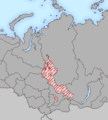
File:Yeniseian map XVII-XX.png
外观
Yeniseian_map_XVII-XX.png (450 × 500像素,文件大小:31 KB,MIME类型:image/png)
文件历史
点击某个日期/时间查看对应时刻的文件。
| 日期/时间 | 缩略图 | 大小 | 用户 | 备注 | |
|---|---|---|---|---|---|
| 当前 | 2009年1月19日 (一) 22:38 |  | 450 × 500(31 KB) | 姫宮南 | {{Information |Description={{en|The map of distribution of en:Yeniseian languages (red) in the XVII century (approximate; hatching) and in the end of XX century (continuous background).}}{{ru|Карта распространения [[:ru:Енис |
文件用途
以下页面使用本文件:
全域文件用途
以下其他wiki使用此文件:
- als.wikipedia.org上的用途
- ar.wikipedia.org上的用途
- be-tarask.wikipedia.org上的用途
- cs.wikipedia.org上的用途
- de.wikipedia.org上的用途
- en.wikipedia.org上的用途
- eo.wikipedia.org上的用途
- es.wikipedia.org上的用途
- fa.wikipedia.org上的用途
- fi.wikipedia.org上的用途
- frr.wikipedia.org上的用途
- fr.wikipedia.org上的用途
- fy.wikipedia.org上的用途
- gl.wikipedia.org上的用途
- hr.wikipedia.org上的用途
- incubator.wikimedia.org上的用途
- it.wikipedia.org上的用途
- ja.wikipedia.org上的用途
- ka.wikipedia.org上的用途
- kv.wikipedia.org上的用途
- la.wikipedia.org上的用途
- lfn.wikipedia.org上的用途
- lt.wikipedia.org上的用途
- mg.wikipedia.org上的用途
- mk.wikipedia.org上的用途
- mrj.wikipedia.org上的用途
- nl.wikipedia.org上的用途
- nn.wikipedia.org上的用途
- no.wikipedia.org上的用途
查看此文件的更多全域用途。


