
File:Azerbaijan topographic map-fr.svg

此 SVG 檔案的 PNG 預覽的大小:757 × 502 像素。 其他解析度:320 × 212 像素 | 640 × 424 像素 | 1,024 × 679 像素 | 1,280 × 849 像素 | 2,560 × 1,698 像素。
原始檔案 (SVG 檔案,表面大小:757 × 502 像素,檔案大小:3.07 MB)
摘要
| 描述 |
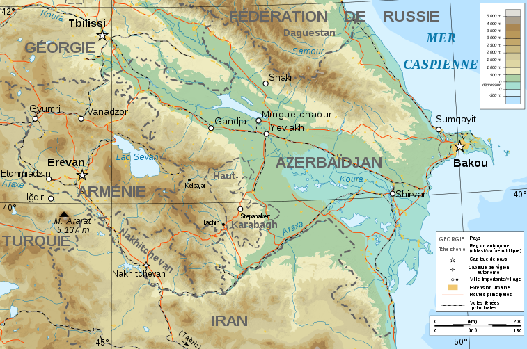
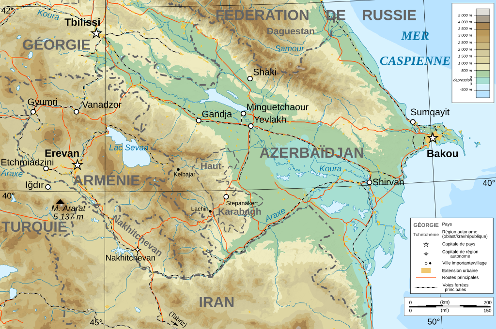
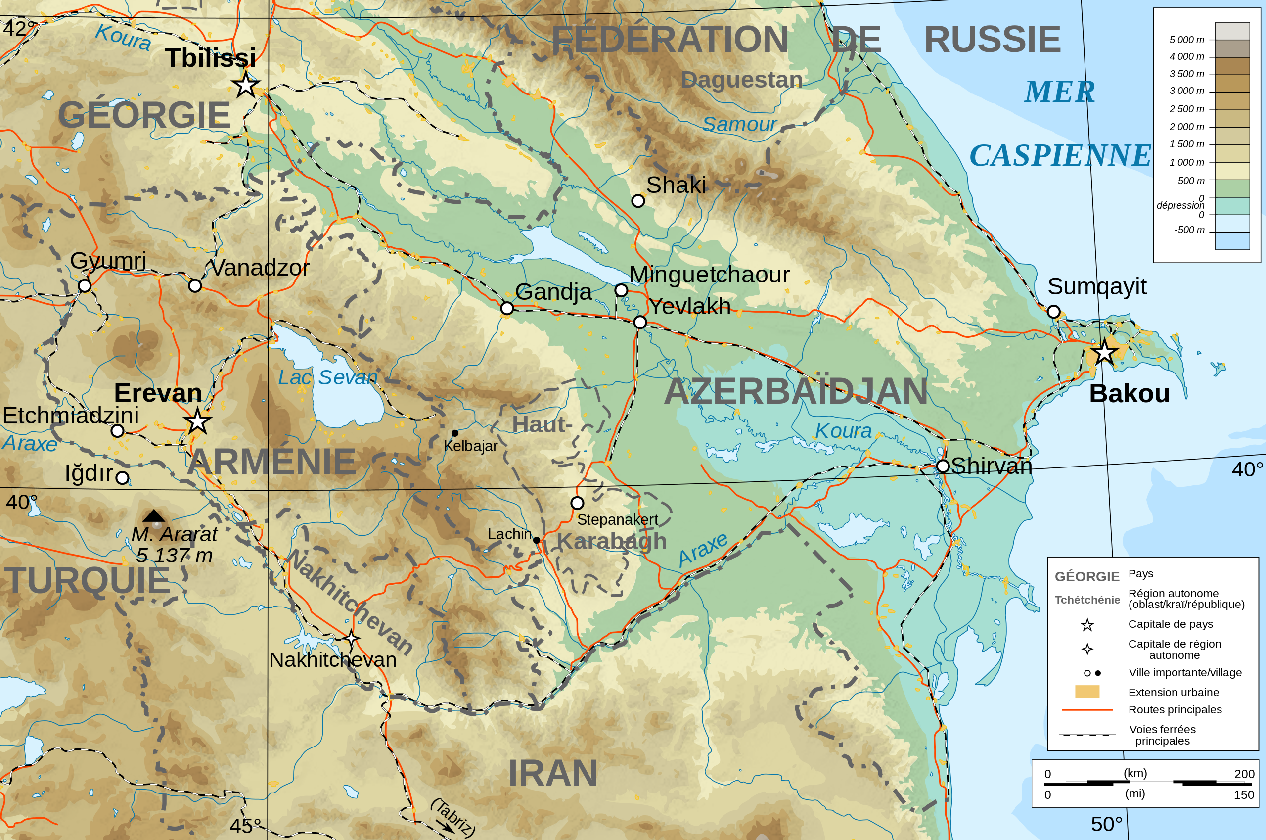
Français : Carte topographique en français de l'Azerbaïdjan et de l'Arménie, avec le Haut-Karabagh en tant que région autonome. |
| 日期 | |
| 來源 |
English: Own work ; Topographic data from the NASA Shuttle Radar Topography Mission (SRTM3 v.2) (public domain) edited with 3DEM, reprojected in UTM with GDAL (GDAL), and vectorized with Inkscape ; UTM projection ; WGS84 datum ; shaded relief (composite image of N-W, W and N lightning positions) ; Reference used for the additional data : * Rivers, cities, railroads, routes, bathymetry : Demis add-on for World Wind (see the approval e-mail and the Demis forum) ; * Borders and coast : World data bank II ; Note : The shaded relief is a raster image embedded in the SVG file. Français : Création personnelle ; Données topographiques de la NASA Shuttle Radar Topography Mission (SRTM3 v.2) (domaine public) éditées avec 3DEM, reprojetées en UTM avec GDAL et vectorisées avec Inkscape ; projection UTM ; WGS84 datum ; relief ombré (image composite d'éclairages du N-O, O et N) ; Références utilisées pour les données complémentaires : * Rivières, villes, chemins de fers, routes, bathymétrie : Demis add-on for World Wind (cf. l'e-mail d'approbation de Demis et le Demis forum) ; * Frontières et côtes : World data bank II ; Note : Le relief ombré est une image bitmap embarquée dans le fichier SVG. |
| 作者 | Bourrichon - fr:Bourrichon) |
| 授權許可 (重用此檔案) |
GFDL / Attribution and Share-Alike required |
| 其他版本 |
|
| SVG開發 |


授權條款
我,本作品的著作權持有者,決定用以下授權條款發佈本作品:

|
已授權您依據自由軟體基金會發行的無固定段落、封面文字和封底文字GNU自由文件授權條款1.2版或任意後續版本,對本檔進行複製、傳播和/或修改。該協議的副本列在GNU自由文件授權條款中。 |
This file is licensed under the Creative Commons Attribution-Share Alike Attribution-Share Alike 4.0 International, 3.0 Unported, 2.5 Generic, 2.0 Generic and 1.0 Generic license.
- 您可以自由:
- 分享 – 複製、發佈和傳播本作品
- 重新修改 – 創作演繹作品
- 惟需遵照下列條件:
- 姓名標示 – 您必須指名出正確的製作者,和提供授權條款的連結,以及表示是否有對內容上做出變更。您可以用任何合理的方式來行動,但不得以任何方式表明授權條款是對您許可或是由您所使用。
- 相同方式分享 – 如果您利用本素材進行再混合、轉換或創作,您必須基於如同原先的相同或兼容的條款,來分布您的貢獻成品。
您可以選擇您需要的授權條款。
檔案歷史
點選日期/時間以檢視該時間的檔案版本。
| 日期/時間 | 縮圖 | 尺寸 | 使用者 | 備註 | |
|---|---|---|---|---|---|
| 目前 | 2008年11月10日 (一) 18:12 | | 757 × 502(3.07 MB) | Bourrichon | + corr légende |
| 2008年11月10日 (一) 18:07 |  | 757 × 502(3.07 MB) | Bourrichon | + Iğdır | |
| 2008年11月10日 (一) 17:45 |  | 757 × 502(3.06 MB) | Bourrichon | + cities | |
| 2008年11月9日 (日) 17:25 |  | 757 × 502(3.06 MB) | Bourrichon | ||
| 2008年11月8日 (六) 16:36 |  | 757 × 502(3.06 MB) | Bourrichon | == Summary == {{Information |Description={{de|Topographische Karte von Aserbaidschan und Armenien, französische Version}}{{en|Topographic map in French of Azerbaijan and Armenia}}{ |
檔案用途
沒有使用此檔案的頁面。
全域檔案使用狀況
以下其他 wiki 使用了這個檔案:
- de.wikibooks.org 的使用狀況
- en.wikipedia.org 的使用狀況
- eo.wikipedia.org 的使用狀況
- fi.wikipedia.org 的使用狀況
- fr.wikipedia.org 的使用狀況
- pcd.wikipedia.org 的使用狀況
- ro.wikipedia.org 的使用狀況
- to.wikipedia.org 的使用狀況