
File:Moundville aerial HRoe 2020.jpg
無更高解析度可提供。
Moundville_aerial_HRoe_2020.jpg (350 × 239 像素,檔案大小:136 KB,MIME 類型:image/jpeg)
摘要
| 描述 |
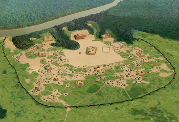
English: Artists conception of the Moundville Site, a Mississippian culture site on the Black Warrior River in Hale County, Alabama. The site was the political and ceremonial center of a paramount chiefdom polity between the 1000 to 1500 CE. The site encompasses 185 acres , consisting of 29 platform mounds around a rectangular plaza and surrounded by a protective bastioned palisade. All rights held by the artist, Herb Roe© 2020. |
| 日期 | |
| 來源 | 自己的作品 |
| 作者 | Herb Roe |
| 拍攝地點 | | 位於此地的本圖片與其他圖片: OpenStreetMap |
|---|
授權條款
我,本作品的著作權持有者,決定用以下授權條款發佈本作品:
此檔案採用創用CC 姓名標示-相同方式分享 4.0 國際授權條款。
- 您可以自由:
- 分享 – 複製、發佈和傳播本作品
- 重新修改 – 創作演繹作品
- 惟需遵照下列條件:
- 姓名標示 – 您必須指名出正確的製作者,和提供授權條款的連結,以及表示是否有對內容上做出變更。您可以用任何合理的方式來行動,但不得以任何方式表明授權條款是對您許可或是由您所使用。
- 相同方式分享 – 如果您利用本素材進行再混合、轉換或創作,您必須基於如同原先的相同或兼容的條款,來分布您的貢獻成品。
檔案歷史
點選日期/時間以檢視該時間的檔案版本。
| 日期/時間 | 縮圖 | 尺寸 | 使用者 | 備註 | |
|---|---|---|---|---|---|
| 目前 | 2020年6月18日 (四) 07:34 | | 350 × 239(136 KB) | Heironymous Rowe | Uploaded own work with UploadWizard |
檔案用途
下列頁面有用到此檔案:
全域檔案使用狀況
以下其他 wiki 使用了這個檔案:
- en.wikipedia.org 的使用狀況
- gl.wikipedia.org 的使用狀況
- incubator.wikimedia.org 的使用狀況
- nl.wikipedia.org 的使用狀況