
File:Kelenken holotype site.png
此为最大尺寸。
Kelenken_holotype_site.png (255 × 362像素,文件大小:47 KB,MIME类型:image/png)
摘要
| 描述 |
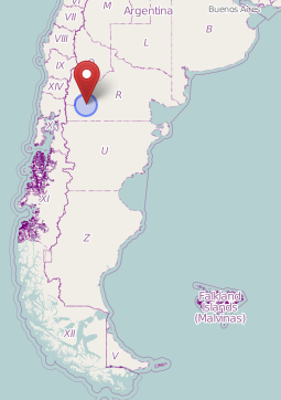
English: Map showing the approximate location (near the village Comallo) where the holotype of Kelenken was found. Nederlands: Kaart waarop bij benadering de vindplaats (in de buurt van het dorpje Comallo) van het holotype van Kelenken te zien is. |
| 日期 | |
| 来源 | OpenStreetMap ([1]) |
| 作者 | OpenStreetMap users |
许可协议
| This work contains information from OpenStreetMap, which is made available under the Open Database License (ODbL).
The ODbL does not require any particular license for maps produced from ODbL data. Prior to 1 August 2020, map tiles produced by the OpenStreetMap Foundation were licensed under the CC-BY-SA-2.0 license. Maps produced by other people may be subject to other licences. |
文件历史
点击某个日期/时间查看对应时刻的文件。
| 日期/时间 | 缩略图 | 大小 | 用户 | 备注 | |
|---|---|---|---|---|---|
| 当前 | 2022年2月11日 (五) 19:16 | | 255 × 362(47 KB) | FunkMonk | Cropped unnecessary top. |
| 2013年5月27日 (一) 18:16 |  | 255 × 534(49 KB) | Amphicoelias | User created page with UploadWizard |
文件用途
以下页面使用本文件:
全域文件用途
以下其他wiki使用此文件:
- ar.wikipedia.org上的用途
- cs.wikipedia.org上的用途
- fr.wikipedia.org上的用途
- he.wikipedia.org上的用途
- hu.wikipedia.org上的用途
- id.wikipedia.org上的用途
- ja.wikipedia.org上的用途
- nl.wikipedia.org上的用途
- pt.wikipedia.org上的用途
- www.wikidata.org上的用途