
File:Adriatic Plate.jpg
預覽大小:626 × 600 像素。 其他解析度:250 × 240 像素 | 501 × 480 像素 | 817 × 783 像素。
原始檔案 (817 × 783 像素,檔案大小:181 KB,MIME 類型:image/jpeg)
摘要
| 描述 |
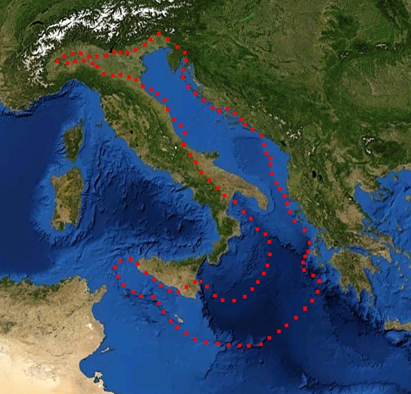
English: boundaries of the Adriatic plate
עברית: גבולות הלוח האדריאטי |
| 日期 | (UTC) |
| 來源 |
Mediterranian_Sea_16.61811E_38.99124N.jpg (July 2012). "Present kinematics of Central and Northern Italy from continuous GPS measurements". Journal of Geodynamics 58: 62-72. Elsevier. ISSN 0264-3707. Retrieved on 12 March 2012. plate boundary map preview |
| 作者 |
|
| 這是一張修飾過的圖片,即本圖片是用軟體修改過後的版本,修改的方式或內容有:crop, plate boundaries。原版圖片來源:Mediterranian Sea 16.61811E 38.99124N.jpg。修改者:דקי。
|
授權條款
| 本圖像屬於公有領域,因其為NASA的World Wind衛星地圖瀏覽器的一張截圖,且使用了公有領域圖層,如Blue Marble、MODIS、Landsat、SRTM、USGS、GLOBE等。
|
 |
| This work was previously under Public Domain, or a Free License. It has been digitally enhanced and/or modified. This derivative work has been (or is hereby) released into the public domain by its author, [[:{{{1}}}:User:{{{3}}}|{{{3}}}]] at the [[:{{{1}}}:|{{{2}}}]] project. This applies worldwide. 在一些國家這可能不合法;如果是這樣的話,那麼:
|
原始上傳日誌
This image is a derivative work of the following images:
- File:Mediterranian_Sea_16.61811E_38.99124N.jpg licensed with PD-WorldWind, PD-retouched-user-w
Uploaded with derivativeFX
檔案歷史
點選日期/時間以檢視該時間的檔案版本。
| 日期/時間 | 縮圖 | 尺寸 | 使用者 | 備註 | |
|---|---|---|---|---|---|
| 目前 | 2011年12月29日 (四) 17:52 | | 817 × 783(181 KB) | דקי | == {{int:filedesc}} == {{Information |Description={{en|boundaries of the Adriatic plate}} {{he|גבולות הלוח האדריאטי}} |Source=*File:Mediterranian_Sea_16.61811E_38.99124N.jpg |Date=2011-12-29 17:47 (UTC) |Author=*[[:File:Mediterrani |
檔案用途
下列頁面有用到此檔案:
全域檔案使用狀況
以下其他 wiki 使用了這個檔案:
- az.wikipedia.org 的使用狀況
- bg.wikipedia.org 的使用狀況
- bn.wikipedia.org 的使用狀況
- ca.wikipedia.org 的使用狀況
- cs.wikipedia.org 的使用狀況
- de.wikipedia.org 的使用狀況
- el.wikipedia.org 的使用狀況
- en.wikipedia.org 的使用狀況
- es.wikipedia.org 的使用狀況
- fa.wikipedia.org 的使用狀況
- fr.wikipedia.org 的使用狀況
- he.wikipedia.org 的使用狀況
- hr.wikipedia.org 的使用狀況
- hu.wikipedia.org 的使用狀況
- it.wikipedia.org 的使用狀況
- ja.wikipedia.org 的使用狀況
- nl.wikipedia.org 的使用狀況
- pl.wikipedia.org 的使用狀況
- pt.wikipedia.org 的使用狀況
- ru.wikipedia.org 的使用狀況
- sh.wikipedia.org 的使用狀況
- sl.wikipedia.org 的使用狀況
- sv.wikipedia.org 的使用狀況
- tr.wikipedia.org 的使用狀況
- uk.wikipedia.org 的使用狀況