
File:The Hermitage, Warkworth - geograph.org.uk - 735173.jpg
The_Hermitage,_Warkworth_-_geograph.org.uk_-_735173.jpg (640 × 426 像素,檔案大小:98 KB,MIME 類型:image/jpeg)
摘要
| 描述 |
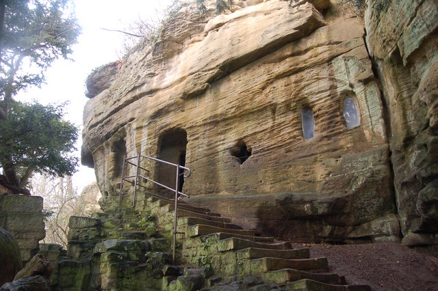
English: The Hermitage, Warkworth From Wikipedia
Warkworth Hermitage is an unusual relic situated on the North bank of the River Coquet in Northumberland, England, close to the village of Warkworth. The Hermitage consists of an outer portion built of stone, and an inner portion hewn from the steep rock above the river. This inner part comprises a chapel and a smaller chamber, both having altars. There is an altar-tomb with a female effigy in the chapel. From the window between the inner chamber and the chapel, and from other details, the date of the work may be placed in the latter part of the 14th century, the characteristics being late Decorated. The traditional story of the origin of the hermitage, attributing it to one of the Bertrams of Bothal Castle in this county, is told in Bishop Percy's ballad The Hermit of Warkworth (1771). The carving in the window is a nativity scene, the female is Mary with the new born child at her breast; the item at her feet is the head of a bull, and the figure at her shoulder is an angel. Of the dedication crosses placed at the time of its construction only one is visible, the alter was plain the crafety is just that. The ballad is to all intents fiction as the chapel was built as a chantry, and occupied by a series of clergy from 1489 to 1536; since that time it has remained as it is today. |
| 日期 | |
| 來源 | From geograph.org.uk |
| 作者 | hayley green |
| 姓名標示 (由许可协议要求) | hayley green / The Hermitage, Warkworth / |
| 拍攝地點 | | 位於此地的本圖片與其他圖片: OpenStreetMap |
|---|
_heading:90.00&language=zh-tw)
| 目標地點 | | 位於此地的本圖片與其他圖片: OpenStreetMap |
|---|
_heading:90.00&language=zh-tw)
授權條款

|
- 您可以自由:
- 分享 – 複製、發佈和傳播本作品
- 重新修改 – 創作演繹作品
- 惟需遵照下列條件:
- 姓名標示 – 您必須指名出正確的製作者,和提供授權條款的連結,以及表示是否有對內容上做出變更。您可以用任何合理的方式來行動,但不得以任何方式表明授權條款是對您許可或是由您所使用。
- 相同方式分享 – 如果您利用本素材進行再混合、轉換或創作,您必須基於如同原先的相同或兼容的條款,來分布您的貢獻成品。
檔案歷史
點選日期/時間以檢視該時間的檔案版本。
| 日期/時間 | 縮圖 | 尺寸 | 使用者 | 備註 | |
|---|---|---|---|---|---|
| 目前 | 2011年2月19日 (六) 09:21 | | 640 × 426(98 KB) | GeographBot | == {{int:filedesc}} == {{Information |description={{en|1=The Hermitage, Warkworth From Wikipedia Warkworth Hermitage is an unusual relic situated on the North bank of the River Coquet in Northumberland, England, close to the village of Warkworth. Th |
檔案用途
下列頁面有用到此檔案:
全域檔案使用狀況
以下其他 wiki 使用了這個檔案:
- en.wikipedia.org 的使用狀況